"Study nature, love nature, stay close to nature. It will never fail you." ~ Frank Lloyd Wright
Below are current and ongoing research projects
Landscape Evolution and Sediment Transport
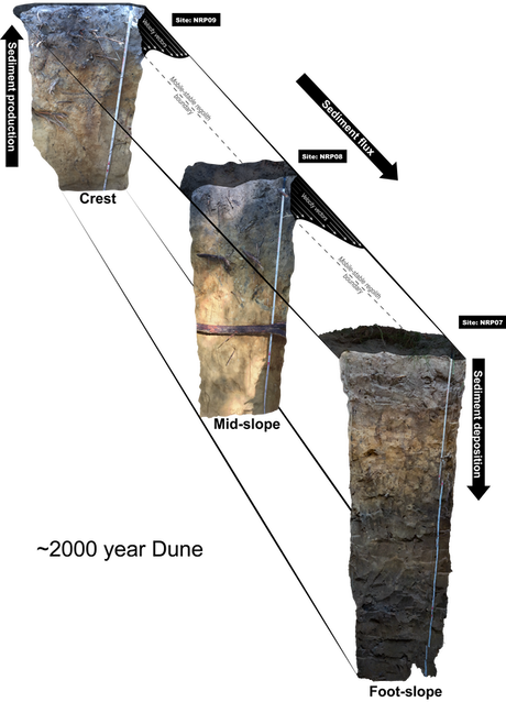
The image depicts three soil profiles along a hillslope catena. Sediments erode from the ridge, transport through the mid-slope and ultimately deposit at the foot-stope position.
Diffuse transport of sediments through soil creep has been studied for nearly 150 years and in that time scientist have derive many mathematical explanations using various assumptions. However, there has been a consistent lack in agreement between applied erosion rates and velocity profiles versus those derived through empirical theory. I aim to determine the mechanisms driving landscape evolution to better understand landscapes. In particular, I have focused my work in Australia's Great Sandy National Park (Cooloola) and K'gari (Fraser Island) QLD, AUS. The coast dune fields provide a premier natural laboratory because of its uniform sediment, continuous chronosequence and (nearly) endless sediment supply. My research looks at the fundamental components of soil movement empirically and through a variety of field base measurements. When these models are refined, I will extend our findings to better understand soil, water and nutrient redistribution.
Lake Sediment Paleoclimate Reconstruction
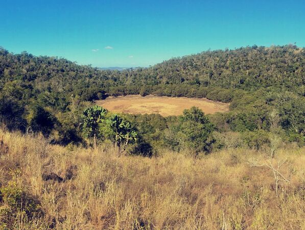
Picture of the Upper Coalstoun Lake in 2018. Note that no water is present in the lake at the time of sampling.
Australia is recognized as the driest inhabited continent with high variability in rainfall, both spatially and temporally. Due to the heterogeneity of rainfall across Australia, the effects of climate change may have dramatic effects on local water supply, agriculture, and ecosystem services. However, the true responses of climate change is unclear because of the lack of understanding of past climate variability and the complex interactions between human disturbances and future climate scenarios. The goal of this project is to better understand the long-term climate variability of eastern Australia’s subtropics by conducting a multi-proxy analysis of lake sediment cores collected from Coalstoun Lakes, QLD, AUS. I am focusing on two main research areas creating a modern hydrological model and evaluating the paleo-climate of the region by utilizing stable isotopes. Combining both hydrology and stable isotopes disciplines, we will provided a high resolution and long term (last two glacial cycles) climate history of eastern Australia subtropics. The implications of our work will directly address frequency, severity, and duration of drought hazards, anthropogenic environmental impacts, and natural and modified climate variability.
Soil Thickness and Transport
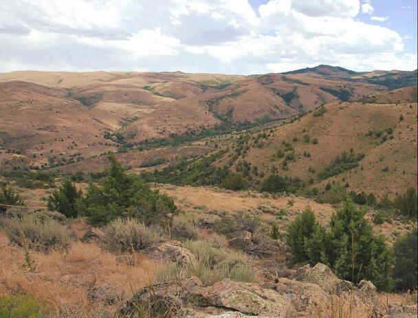
Picture of Johnston Draw a granitic watershed within the Reynolds Creek Critical Zone Observatory (photo credit: Hugo Sindelar).
Soil thickness is a result between soil production ( the conversion of bedrock to soil via chemical and physical weathering), and the flux of soil out of the system. Soil thickness is a key parameter in many environmental disciplines. It is critical in hillslope stability, landscape evolution, drainage density, channel activation, runoff response times, plant-available water, rooting depth, and the storage of nutrients. Despite its importance, spatially distributed soil thickness data are rarely obtained due to the challenges associated with time, cost, and the difficulty in physically obtaining these measurements. I aim to improve the understanding of the mechanisms driving soil thickness/transport and determine a universal model to extrapolate soil thickness spatially within all ecosystems, climates and lithologies. These questions are currently being assessed through high-resolution elevation data, soil pit excavations and mass balance approaches.
Soil Organic Carbon Stocks
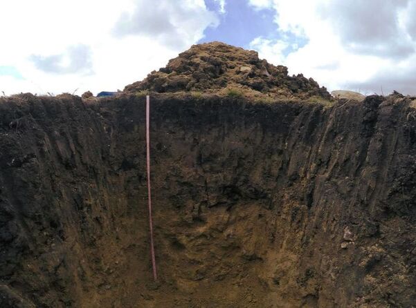
Soil pit (JDT 6a) within the Reynolds Creek Critical Zone Observatory used to determine total SOC stocks.
Soils are the largest terrestrial reservoirs, containing ~2,400 Pg C globally, which is more than both the above ground biomass and atmosphere combined. In fact, as much as 75% of the terrestrial stocks are organic. However, absolute stocks estimates are difficult to determine due to uncertainty surrounding soil organic carbon (SOC) spatial and temporal distribution. In particular, SOC studies have focus on near surface stocks but fail to include deep soils (> 30 cm) which creates large uncertainty in how anthropogenic perturbations and/or climate change may shift soils to a source or a sink of atmospheric carbon. Currently, my projects are set in semi-arid environments (Reynolds Creek, ID, USA) where my work aims to determine total SOC stocks for the entire soil profile and evaluate topographic influences. In addition, I hope to provide new and novel approaches for determining accurate total SOC estimates across complex terrains with minimum time, effort, and cost that can help infer local and regional carbon flux models.
Remote Sensing and Surface Processes - Mapping
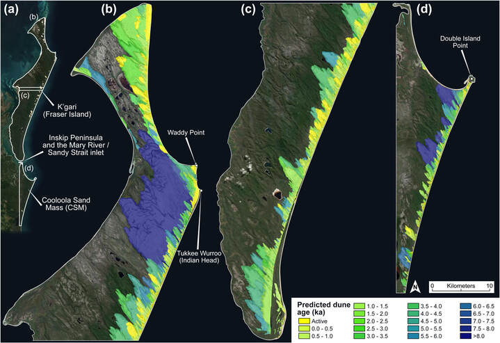
Estimated dune ages on K'gari (Fraser Island) and the Cooloola Sand Mass in SE Queensland Australia, see Patton et al. (2022) for more detail.
When high resolution digital elevation models (DEMs) became readily available in the early 2000's, it provided a new level of detail in the landscape that had never been observed with traditional geomorphic mapping formats. I am interested in the application of LiDAR-based DEMs and evaluating the landscape expressions that may indicate surface processes and relative age. In particular, the south eastern Queensland dune fields provide an ideal location due to its wonderfully preserve chronosequences (extending well into the Pleistocene) and access to climate and DEM data. The results from our work will help create new techniques to more accurately understand landscapes and their processes but will be a important foundation for future research within this field area.
Evaluating δ18O and δ13C variations within modern snails shells paleoclimate reconstruction
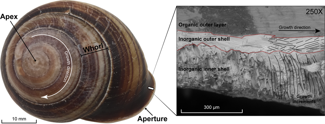
Image of a Biggenden Banded snail
(Figuladra bayensis) shell collected at Coalstoun Lakes National Park in Queensland, Australia. The insert is from a scanning electron microscope (SEM) image showing the growth patterns of the aragonite shell.
Gastropods are utilized to infer paleoclimate variability due to the preservation and incorporation of stable isotopes in their aragonite shells. Analyses along the growth axis of larger gastropods have been suggested to contain high-resolution records of local seasonal climate variability and the organism’s biological life cycle. In this study, I look at δ18O and δ13C stable isotopes collected from snail shells along their growth axis and place those values in context with time using radiocarbon (14C) dating. The results of this work allows the nuances of the stable isotope record to be more clearly interpreted and therefore used as a palaeoenvironmental proxy.
Using in-situ and meteoric 10Be to define the mobile-stable regolith boundary
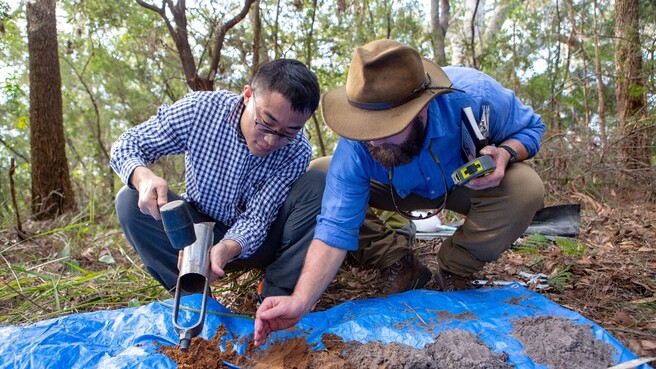
Image depicts Dr. Dongliang Ning and myself collecting soil/dune samples to take back to the lab.
Understanding physico-chemical properties of soil profiles are fundamental to evaluate long-term landscape evolution in response to climate, tectonics and human activities. The thickness of the mobile regolith, the portion of the soil profile that is experiencing down slope movement, and the stable regolith, weathered (bedrock or saprolite) material that is ultimately incorporated into the mobile regolith after weathering, is a key parameter for soil production/erosion in hillslope settings. Delineating the mobile-stable regolith boundary is, however, increasingly difficult to determine as soil thickens >1 m such as in hollows, valleys, basins, and convergent hillslopes. This study will evaluate in-situ and meteoric 10Be depth profiles in Cooloola Sand Mass coastal dune fields, SE Queensland, in the aim of developing a new quantitative approach defining the mobile-stable regolith boundary. When successful, the developed new method can be utilized to quantify the mobile regolith layer, which will be used to mass balance models of soil erosion and deposition in landscape evolution studies.
Reconstructing fire history and its effect on sediment transport
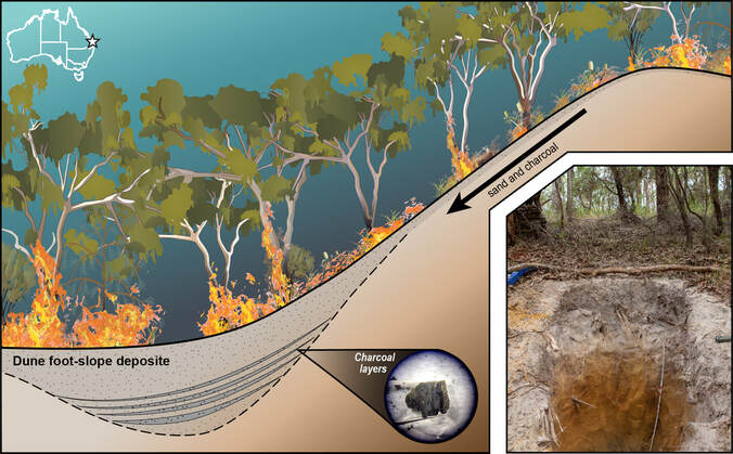
Conceptual diagram showing how sediment transport theory can explain how charcoal are deposited at the base of hillslopes. In these depositional areas, sediment cores or soil profiles can be excavated to determine a fire history, see Patton et al. (2023) for more detail.
Fire regimes are becoming increasingly frequent and more severe and it is important to understand how the landscape will respond. The goal of this research was to determine terrestrial fire history at the Cooloola Sand Mass (CSM) and its associated effect on landscape changes. This study has helped to pioneer a new approach to expanding fire histories from areas where fire is an exotic import (swamps/lakes) into the parts of the landscape where fire may be the dominant geological and ecological process. We have achieved this goal by radiocarbon (14C) dating charcoal fragments in the depositional foot-slope of dunes .The outcomes produced in this study was the first fire history record from a depositional foot-slope on a dune. In addition, the dated records of fire provides a direct process for landscape evolution and will offer answers regarding fire frequency. Future work will take us to the center of Australia to see if this approach works on continental dunes.
